Project Overview
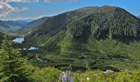
The Pemberton Hills target is a 6.5km long 1.5km thick lithocap of high-level, advanced argillic alteration within Mesozoic-age andesitic volcanic rocks. In British Columbia lithocaps over porphyry systems, especially of this age, are quite rare as they have been eroded away. However, they are very common in young porphyry systems in South America and Southeast Asia. Extensive Terraspec Halo studies of the altered rock within the zone confirm the alteration is advanced argillic and similar to that at both Hushamu, Red Dog and Northwest Expo. Evidence of a buried porphyry copper deposit is the presence of anomalous copper at the end of a 200m deep drill hole within the lithocap and anomalous copper within drill holes which penetrate the lithocap. Typically, the lithocaps in other regions are unmineralized. At that time, it was thought that this porphyry system was upright.
Drilling in 2021 confirmed a large, thick lithocap consistent with an underlying porphyry system. Pyrite-rich breccias, remobilized metals in narrow veins, and clay minerals intersected in the 2018 and 2021 drilling programs indicating higher temperatures and high acidity are interpreted as emanating from a porphyry system at depth.
The geological model has evolved significantly since 2021, when four drill holes were completed in the lithocap occurring at the top of the Pemberton Hills porphyry system. A lithocap is an alteration zone comprised variably of kaolinite, dickite, smectite, pyrite and silica typically found above buried porphyry deposits. Observation of the geomorphology, geologic and alteration mapping and reinterpretation of a 2005 regional airborne magnetic survey led to a new interpretation that the lithocap is tilted approximately 30 to 50 degrees to the southwest with a greater lateral extent than previously interpreted (6.5km long by 1.5km thick), indicating that a huge hydrothermal system created it.
This reinterpretation was a result of the integration of the results of NorthIsle’s work with a previously confidential report (until Dec.31, 2023) completed by researchers from Lakehead University, the University of Tasmania’s Centre for Ore Deposits and Earth Sciences, UBC’s Mineral Deposit Research Unit and the BC Geological Survey. Utilizing clay analysis vectoring, elemental vectoring, and mapping of alteration, the centre of and direction of hydrothermal up flow was determined. Utilizing this integrated model, the indications are that the core of the porphyry system is to the northeast of the location of previous work on the target. Field mapping to the northeast encountered a quartz-sericite-pyrite (QSP) alteration zone 1.5km wide extending 2.5 km northeast of the lithocap. This zone was coincident with vectoring indicators and is typical of peripheral (QSP) alteration occurring peripheral to the mineralized cores of porphyry systems. The map below shows an updated interpretation of the surface geology of the Pemberton Hills area as well as the location of 2022 geophysical survey lines.

Interpretation of structures local to the Pemberton Hills area suggests block faulting consistent with regional structures. The diagram below shows the hypothesized dip and faulting of the lithocap and potential porphyry system source.

As a result, of this new research and reinterpretation NorthIsle specified a target area for geophysics which was anticipated to help identified the key subsurface structures which might support the overall thesis. The survey area encompassed a total of 23.55 line-kilometers covering an area of 4.4km by 2.2km. (see map)
During late 2022, Northisle contracted Simcoe Geosciences who completed a surface geophysics program consisting of ground magnetics and wireless IP in the area to the northeast of the lithocap and covering the QSP alteration zone.. Results from the geophysical survey are consistent with the surface geological mapping and reinterpretation, with chargeability and magnetic anomalies coincidental within the QSP alteration one. Northisle identified 15 drill targets during this 2022 geophysical survey at Pemberton Hills.
The following VRIFY presentation provides an overview of the exciting target at Pemberton Hills and shows the geophysical survey results in the context of surface mapping and other previous work.
CURRENT WORK PROGRAM
The next steps are to complete additional infill drilling in order to upgrade the resource ahead of a potential future pre-feasibility study.
All scientific information contained on this website has been reviewed and approved by Robin Tolbert, P.Geo., Vice President, Exploration of NorthIsle Copper and Gold Inc. who is a “qualified person” as defined by National Instrument 43 – 101 of the Canadian Securities Administration.
Note that the preliminary economic assessment is preliminary in nature. It includes inferred mineral resources that are considered too speculative geologically to have the economic considerations applied to them that would enable them to be categorized as mineral reserves, and there is no certainty that the preliminary economic assessment will be realized.